MODEL APPLICATION EXAMPLE

Output Files

Home

Registration

Background

Processes

   Flow Routing

   Sediment Routing

References

Example

   Input Files

   Output Files

Download

Feedback


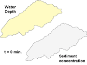
CASC2D-SED creates the following output files:

(1) Summary file: contains information on the simulation parameters, channel topology inferred from the link and node maps and the final results of the hydrological and erosion components (see Table 6).

(2) Flow and sediment flow files: containing the water flow and sediment flow at the outlet.  Results can optionally be written at other internal locations inside the watershed (see Table 6).

(3) Time-series grids: They are optional and represent simulation values at predetermined times.  Output raster maps include: water depth, rainfall rates, accumulated infiltrated depth, total suspended sediment volume, total deposited sediment volume, total sediment flux and concentration.  For each size fraction, the amounts of suspended sediment, deposited sediment, sediment flux and sediment concentration are calculated as well (see Table 7).  Time series grids can be later used as input in an animated file for the hydrological and sediment dynamics during the simulated  event.  See a MPEG animation of the simulated storm showing the rainfall rates, accumulated infiltration, water depth in overland and channels, and sediment concentration by volume.

NOTE: The links in the last paragraphs are connected to the output files included in the downloadable example files in this web site.

Table 6. CASC2D-SED input and output text files.


Project name

File variable

Description

Output

Text Files

SUMMARY

Summ_file

Simulation summary file

DISCHARGE_OUT

dis_out_file

Hydrograph at outlet and, if selected,  at internal locations [m3/s]

SEDIMENT_OUT

sed_out_file

Sedigraph at outlet and, if selected, at internal locations [m3/s]


Table 7. CASC2D-SED output raster maps.


Project name

File

 variable

Computed

Variable

 (units)

Time series grid

(units)

Description

Time Series Output Grids

RAINFALL

rname

rint[j][k]

(m/s)

rint[j][k] * 3600000

(mm/h)

Rainfall rates at cell (j,k)

INF_DEPTH

vinfname

vinf[j][k]

(m)

vinf[j][k] * 1000

(mm)

Infiltrated water at cell (j,k)

WATER_DEPTH

dname

h[j][k] or hch[j][k]

(m)

h[j][k] or hch[j][k]

(m)

Depth of water at cell (j,k)

CONCENTRATION

SedConcName

1SedConc[i][j][k]

(mg/l)

SedConcp[i][j][k]

(mg/l)

Fraction i sediment conc. at cell (j,k)

tSedConcName

2t_SedConc[i][j][k]

(mg/l)

t_SedConc[i][j][k]

(mg/l)

Total sediment concentration at cell (j,k)

SUSPENDED

SusSedName

SusSed[i][j][k]

(m3)

SusSed[i][j][k]

* 2.65 * 1E6 / (Dx)2

(gr/m2)

Fraction i suspended sed. at cell (j,k)

tSusSedName

t_SusSed[j][k]

(m3)

t_SusSed[j][k]

(m3)

Total suspended sed. at cell (j,k)

DEPOSITED

DepSedName

DepSed[i][j][k]

(m3)

DepSed[i][j][k]

* 2.65 * 1E6 / (Dx)2

(gr/m2)

Fraction i deposited sed. at cell (j,k)

tDepSedName

t_DepSed[j][k]

(m3)

t_DepSed[j][k]

(m3)

Total deposited sed. at cell (j,k)

FLUX

SedFluxName

SedFlux[i][j][k]

(m3/s)

SedFlux[i][j][k]

(m3/s)

Fraction i sediment flux at cell (j,k)

tSedFluxName

t_SedFlux[j][k]

(m3/s)

t_SedFlux[j][k]

(m3/s)

Total sediment flux at cell (j,k)

NETEROS

tNetErosName

3t_NetEros[j][k]

(mm)

t_NetEros[j][k]

(mm)

Net erosion at cell (j,k)


1


 2


 3


Home | Registration | Background | Processes | References | Example | Download | Feedback

Department of Civil and Environmental Engineering - Colorado State University
Fort Collins, Colorado 80523-2028 USA (970) 491-5048
Last updated: 25 August 2006