

Access to properly functioning water and sanitation systems is critical to public health and community development. Approximately 30% of the world's population lacks access to safely managed drinking water systems, and 55% lacks access to safely managed sanitation systems. Because most people who lack access live in rural areas of the majority world, improving access requires implementation of sustainable, low-cost, and reliable systems. It also requires development methods that are community-driven and broadly beneficial. We are working to train engineers and development workers in contextual water, sanitation, and hygiene (WASH) methods. We provide technical guidance through various organizations for WASH projects around the world and support the Water and International Development (WAID) graduate program at Colorado State University.
- Tipitapa, Nicaragua. Provided technical review of water and sanitation system plans for a proposed medical clinic campus (2025)
- Dida Hara, Ethiopia. Provided technical review of a point-of-use biosand filter system design (2024)
- Mai Mahiu, Kenya. Assisted with community stormwater improvements after failure of railway embankments and associated flooding disaster (2024)
- Ngagara and Gitega, Burundi. Assisted with water and sanitation system masterplanning for university campus serving 5000 students and proposed campus serving up to 15,000 students (2022)
- Kijabe, Kenya. Provided technical guidance focused on improving drinking water quality and reliability as well as sustainable wastewater disposal for an pediatric orthopedic hospital campus (2021)
- El Pital, El Salvador. Provided technical guidance for senior design project focusing on the design of water supply systems for a small rural community (2018 – 2019)
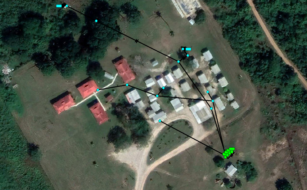
- Belmopan, Belize. Developed water supply and sanitation master plans for a K-12 school campus (2018)
- Lesoit, Tanzania. Planned water supply system for a small Maasai community (2017)
- Murcia, Philippines. Developed water supply and wastewater master plans for a proposed orphanage campus (2017)
- Chogoria, Kenya. Provided technical guidance for water supply and wastewater master plans for a hospital complex and associated housing (2016)
- Gulbarga, India. Provided technical guidance for water and wastewater systems for a goat farm cooperative (2015)
- Bomet, Kenya. Provided technical guidance and review for an evaluation of water and wastewater systems for a hospital complex (2013 – 2015)
- Nkoltang, Gabon. Developed water and wastewater master plans for large campus including an orphanage, schools, medical clinic, housing for widows/widowers, and other facilities (2011)
- Kijabe, Kenya. Developed 10-year master plan for water and wastewater systems of a large hospital complex and associated community (2010 – 2014)
- La Laguneta and El Chile, El Salvador. Provided technical guidance for Engineers Without Borders project to improve water supplies for two small communities (2005 – 2009)
- Zacapa, Guatemala. Assessed condition and planned improvements for the water supply system of orphanage campus and assisted with preliminary design of wastewater improvements (2002)
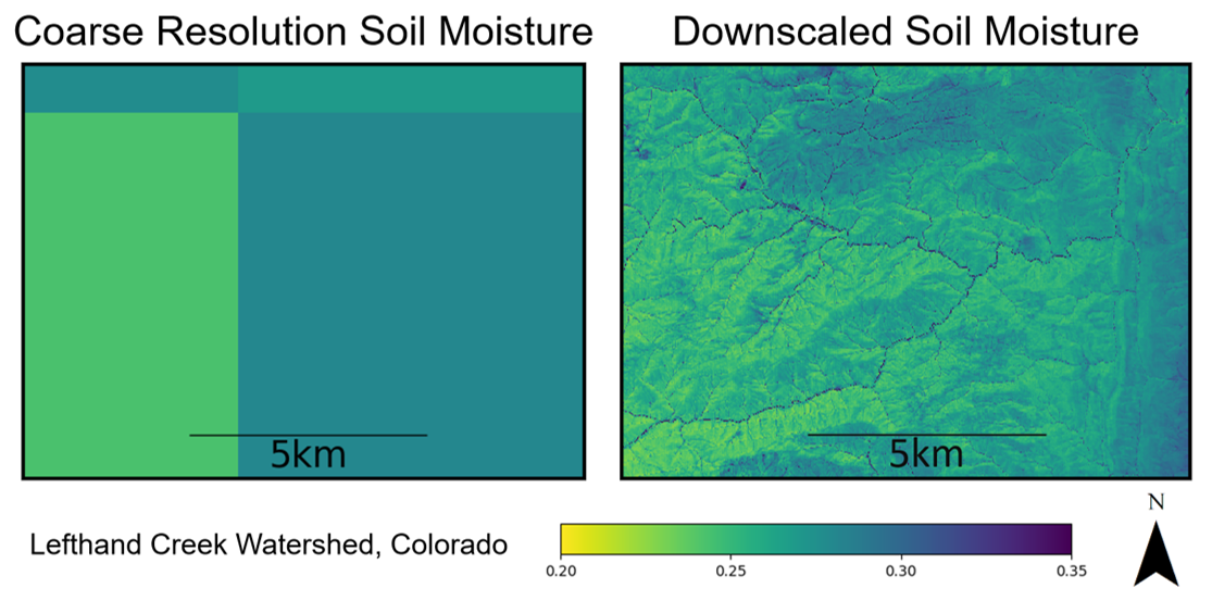
Soil moisture is arguably the most central variable in hydrology because it affects both the land-surface energy balance and water balance. It impacts the production of runoff at the ground surface, transpiration rates from crops and other vegetation, and recharge to shallow aquifers. Unfortunately, direct measurement of soil moisture patterns at the spatial scale of most practical applications is difficult. In-situ methods observe soil moisture only at the probe locations, and interpolating between such measurements is often unreliable. In contrast, satellite remote sensing methods typically observe soil moisture at very coarse spatial resolutions and must be downscaled to reach adequate resolutions for many applications. We are studying the physical processes that control soil moisture, statistical properties of soil moisture patterns, and methods to interpolate and downscale soil moisture observations. As part of this effort, we have developed a patented soil moisture downscaling method that is now used commercially. Understanding the spatial patterns and temporal dynamics of soil moisture benefits water resources planning, flood forecasting, land management, and other applications.
- Bindner, J.R., H.E. Proulx, K. Wickham, J.D. Niemann, J. Scalia, T.R. Green, and P.J. Grazaitis, 2025, "Dependence of Soil Moisture and Strength on Topography and Vegetation Varies within a SMAP Grid Cell," Hydrology, 12(34), 1-24, doi: 10.3390/hydrology12020034.
- Fischer, S., J. D. Niemann, J. Scalia, M.D. Bullock, H.E. Proulx, B. Kim, T.R. Green, and P.J. Grazaitis, 2025, "Assessing the Influence of Model Inputs on Performance of the EMT+VS Soil Moisture Downscaling Model for a Large Foothills Region in Northern Colorado," Journal of Hydrology, 650, 132397, doi: 10.1016/j.jhydrol.2024.132397.
- Sahaar, S.A., and J.D. Niemann, 2024, "Estimating Rootzone Soil Moisture by Fusing Multiple Remote Sensing Products with Machine Learning," Remote Sensing, 16, 3699, doi: 0.3390/rs16193699.
- Bullock, M., J. Scalia IV, J.D. Niemann, 2024, "Predicting Unsaturated Soil Strength for Mobility Assessments," Journal of Terramechanics, 115. 100977, doi: 10.1016/j.jterra.2024.100977.
- Pauly, M.J., J.D. Niemann, J. Scalia, T.R. Green, R.H. Erskine, A.S. Jones, and P.J. Grazaitis, 2020, “Enhanced Hydrologic Simulation May Not Improve Downscaled Soil Moisture Patterns without Improved Soil Characterization,” Soil Science Society of America Journal, 84:672-689, doi: 10.1002/saj2.20052.
- Deshon, J.P., J.D. Niemann, T.R. Green, A.S. Jones, and P.J. Grazaitis, 2020, “Stochastic Analysis and Probabilistic Downscaling of Soil Moisture,” Journal of Hydrology, 585, 124771, 1-13, doi: 10.1016/j.jhydrol.2020.124711.
- Grieco, N.R., J.D. Niemann, T.R. Green, A.S. Jones, and P.J. Grazaitis, 2018, “Hydrologic Downscaling of Soil Moisture using Global Datasets without Site-Specific Calibration,” Journal of Hydrologic Engineering, 23(11), 1-13, 04018048, doi:10.1061/(ASCE)HE.1943-5584.0001702.
- Hoehn, D.C., J.D. Niemann, T.R. Green, A.S. Jones, and P.J. Grazaitis, 2017, “Downscaling Soil Moisture over Regions that Include Multiple Coarse-Resolution Grid Cells,” Remote Sensing of Environment, 199(C), 187-200, doi: 10.1016/j.rse.2017.07.021.
- Cowley, G.S., J.D. Niemann, T.R. Green, M.S. Seyfried, A.S. Jones, and P.J. Grazaitis, 2017, “Impacts of Precipitation and Potential Evapotranspiration Patterns on Downscaling Soil Moisture in Regions with Large Topographic Relief,” Water Resources Research, 53(2), 1553-1574, doi: 10.1002/2016WR019907.
- Ranney, K.J., J.D. Niemann, B.M. Lehman, T.R. Green, and A.S. Jones, 2015, “A Method to Downscale Soil Moisture to Fine-Resolutions using Topographic, Vegetation, and Soil Data,” Advances in Water Resources, 76, 81-96, doi: 10.1016/j.advwatres.2014.12.003.
- Traff, D.C., J.D. Niemann, S.A. Middlekauff, B.M. Lehman, 2015, “Effects of Woody Vegetation on Shallow Soil Moisture at a Semiarid Montane Catchment,” Ecohydrology, 8, 935-947, doi: 10.1002/eco.1542.
- Werbylo, K.L., and J.D. Niemann, 2014, “Evaluation of Sampling Techniques to Characterize Topographically-Dependent Variability for Soil Moisture Downscaling,” Journal of Hydrology, 516, 304-316, doi: 10.1016/j.jhydrol.2014.01.030.
- Coleman, M.L., and J.D. Niemann, 2013, “Controls on Topographic Dependence and Time-Instability in Catchment-Scale Soil Moisture Patterns,” Water Resources Research, 49, 1-18, doi:10.1002/wrcr.20159.
- Busch, F.A., J.D. Niemann, and M.L. Coleman, 2012, “Evaluation of an EOF-Based Method to Downscale Soil Moisture Patterns Based on Topographical Attributes,” Hydrologic Processes, 26, 2696-2709, doi: 10.1002/hyp.8363.
- Coleman, M.L., and J.D. Niemann, 2012, “An Evaluation of Nonlinear Methods for Estimating Catchment-Scale Soil Moisture Patterns Based on Topographic Attributes,” Journal of Hydroinformatics, 14, 3, 800-814, doi: 10.2166/hydro.2012.145.
- Melliger, J.J., and J.D. Niemann, 2010, “Effects of Gullies on Space-Time Patterns of Soil Moisture in a Semiarid Grassland,” Journal of Hydrology, 389, 289-300, doi: 10.1016/j.jhydrol.2010.06.006.
- Perry, M.A., and J.D. Niemann, 2008, “Generation of Soil Moisture Patterns at the Catchment Scale by EOF Interpolation,” Hydrology and Earth System Sciences, 12, 39-53, doi: 10.5194/hess-12-39-2008.
- Jawson, S.D., and J.D. Niemann, 2007, “Spatial Patterns from EOF Analysis of Soil Moisture at a Large Scale and Their Dependence on Soil, Land-Use, and Topographic Properties,” Advances in Water Resources, 30(3), 366-381, doi: 10.1016/j.advwatres.2006.05.006.
- Perry, M.A., and J.D. Niemann, 2007, “Analysis and Estimation of Soil Moisture at the Catchment Scale Using EOFs,” Journal of Hydrology, 334, 388-404, doi: 10.1016/j.jhydrol.2006.10.014.
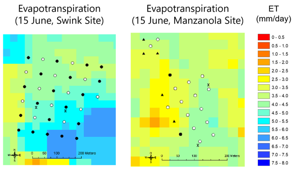
Many irrigated agricultural regions around the world face challenging water problems ranging from groundwater depletion to waterlogging and salinization associated with shallow water tables. Shallow water tables can also increase evapotranspiration from uncropped areas, which may represent a significant nonbeneficial consumptive use of water. Remote sensing methods are excellent resources for confronting these problems from field to regional scales. We are researching the use of optical and thermal remote sensing for estimating evapotranspiration and soil moisture in agricultural regions. We are also using NASA’s Gravity Recovery and Climate Experiment (GRACE) mission to explore groundwater depletion in regions that rely on groundwater. Ultimately, this research is expected to improve our understanding of the water balance in agri-ecological systems and numerical models that are used to evaluate potential solutions to groundwater depletion, waterlogging, and salinization problems.
- Khandelwal, P., J.D. Niemann, D.J. Mulla, S. Pallickara and S. Pallickara, 2025, "Subterra: Estimating Soil Moisture at Root Zone Depths Using Science-Guided Learning," IEEE Conference on Artificial Intelligence, 328-334, doi: 10.1109/CAI64502.2025.00060.
- Ukasha, M. J.A. Ramirez, and J.D. Niemann, 2025, "Detection and Characterization of Scale-Invariant Behaviour and Stochastic Downscaling of Terrestrial Water Storage Anomalies from GRACE and GPS," International Journal of Remote Sensing, 46(4), 1543-1573, doi: 10.1080/01431161.2024.2433752.
- Ukasha, M., J.A. Ramirez, and J.D. Niemann, 2023, "An Improved Rescaling Algorithm for Estimating Groundwater Depletion Using the GRACE Satellite," International Journal of Remote Sensing, 44(3), 1069-1088, doi: 10.1080/01431161.2023.2174387.
- Ukasha, M., J.A. Ramirez, and J.D. Niemann, 2022, "Temporal Variations of NDVI and LAI and Interactions with Hydroclimatic Variables in a Large and Agro-Ecologically Diverse Region," Journal of Geophysical Research Biogeosciences, 127(4), e2021JG006395, doi: 10.1029/2021JG006395.
- Sahaar, A.S., J.D. Niemann, and A. Elhaddad, 2022, “Using Regional Characteristics to Improve Uncalibrated Estimation of Rootzone Soil Moisture from Optical/Thermal Remote-Sensing," Remote Sensing of Environment, 273, 112982, doi: 10.1016/j.rse.2022.112982.
- Sahaar, A.S., and J.D. Niemann, 2020, “Impact of Regional Characteristics on the Estimation of Root-Zone Soil Moisture from the Evaporative Index or Evaporative Fraction,” Agricultural Water Management, 368, 106225, doi: 10.1016/j.agwat.2020.106225.
- Coleman, M.L., T.R. Green, O. David, W.H. Merkel, Q.D. Quan, K. Rojas, and J.D. Niemann, 2016, “Deploying the WinTR-20 Computational Engine as a Web Service,” Applied Engineering in Agriculture, 32(5), 601-608. doi:10.13031/aea.32.11258.
- Alburn, N.E., J.D. Niemann, and A. Elhaddad, 2015, “Evaluation of a Surface Energy Balance Method Based on Optical and Thermal Satellite Imagery to Estimate Root-Zone Soil Moisture,” Hydrologic Processes, 29, 5354-5368, doi: 10.1002/hyp.10562.
- Niemann, J.D., B.M. Lehman, T.K. Gates, N.U. Hallberg, and A. Elhaddad, 2011, “Impact of Shallow Groundwater on Evapotranspiration Losses from Uncultivated Land in an Irrigated River Valley,” Journal of Irrigation and Drainage Engineering, 137, 501-512, doi: 10.1061/(ASCE)IR.1943-4774.0000356.
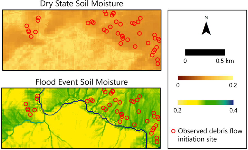
Extreme precipitation events and associated floods are critical considerations for infrastructure design and public safety. For instance, hydrologic models are used in dam safety evaluations to determine the flow rates that spillways must safely convey. The predictions from such models involve significant uncertainty, particularly in mountainous basins, due to difficulties in estimating realistic design storms, the active streamflow production mechanisms, and the flood-wave propagation rates. Extreme precipitation can also initiate landslides and debris flows in mountainous watersheds. For example, a September 2013 storm caused more than 1100 debris flows in the Colorado Front Range. We are developing modeling approaches that more accurately simulate runoff production for major flood events in Colorado’s mountainous basins. These modeling approaches are being used by Colorado Dam Safety as the basis for their new hydrologic modeling guidelines. We are also developing probabilistic tools to predict landslide initiation and runout locations using downscaled soil moisture patterns, and we are formulating new approaches to rapidly predict flood inundation areas. Our flood inundation mapping methods are being used real-time by the Army Corps of Engineers over large portions of the globe.
- Irvin IV, B.C., J.D. Niemann, M.A. Perry, K.E. Bauer, and W.T. McCormick III, 2023, "Parameter Estimation for Models of Major Rainfall Induced Floods in Ungaged Mountain Basins of Colorado," Journal of Hydrology: Regional Studies, 45, 101300, 1-22, doi: 10.1016/j.ejrh.2022.101300.
- Timilsina, S., J.D. Niemann, S.L. Rathburn, F.K. Rengers, and P.A. Nelson, 2021, “Modeling Hydrologic Processes Associated with Soil Saturation and Debris Flow Initiation During the September 2013 Storm, Colorado Front Range,” Landslides, 18(5), 1741-1759, doi: 10.1007/s10346-020-01582-5.
- Woolridge, D.D., J.D. Niemann, M.A. Perry, K.E. Bauer, and W.T. McCormick III, 2020, “Identifying Runoff Production Mechanisms for Dam Safety Applications in the Colorado Front Range,” Journal of Hydrologic Engineering, 05020016, doi: 10.1061/(ASCE)HE.1943-5584.0001958.
- Follum, M.L., A.A. Tavakoly, J.D. Niemann, and A.D. Snow, 2016, “AutoRapid: A Model for Prompt Streamflow Estimation and Flood Inundation Mapping over Regional to Continental Extents,” Journal of the American Water Resources Association, 1-20, doi: 10.1111/1752-1688.12476.
A key element in watershed modeling is transforming the runoff that is produced across a watershed into a streamflow hydrograph at the watershed outlet. Traditional lumped models neglect explicit representation of the basin structure in modeling this transformation, while fully distributed models use cumbersome approximations of the St. Venant equations. We are exploring an intermediate approach called spatially-distributed travel time models. This approach explicitly represents the flow paths within the basin and moves the flow using travel times derived from the St. Venant equations. Thus, it can incorporate the effects of different channel network structures or even stormwater gutters and pipes. However, it does not require a numerical solution of the St. Venant equations. This research is expected to fill a gap in current modeling capabilities and broaden the range of practical applications that can be modeled for both natural and urban basins.
- Chong, P., J. Gironas, and J.D. Niemann, 2022, "A Spatial Analysis of Dispersion Mechanisms in the Hydrologic Response Using a Spatially Distributed Travel Time Model," Water Resources Research, 58, doi: 10.1029/2021WR029891.
- Czyzyk, K.A., D. Mirosi, A. Abdoulhak, S. Hassani, J.D. Niemann, and J. Gironás, 2020, “Impacts on Channel Network Type on the Unit Hydrograph,” Water, 12(3), 669, 1-27, doi: 10.3390/w12030669.
- Bunster, T., J. Gironas, and J.D. Niemann, 2019, "On the Influence of Upstream Flow Contributions in Spatially Distributed Travel Time Models for Hydrograph Prediction,” Water Resources Research, 55, doi: 10.1029/2018WR024510.
- Zuazo, V., J. Gironás, and J.D. Niemann, 2014, “Assessing the Impact of Travel Time Formulations on the Performance of Spatially Distributed Travel Time Methods Applied to Hillslopes,” Journal of Hydrology, 519, 1315–1327, doi: 10.1016/j.jhydrol.2014.09.035.
- Gironás, J., J.D. Niemann, L.A. Roesner, F. Rodriguez, and H. Andrieu, 2010, “Evaluation of Methods for Representing Urban Terrain in Stormwater Modeling,” Journal of Hydrologic Engineering, 15, 1, 1-14, doi: 10.1061/(ASCE)HE.1943-5584.0000142.
- Gironás, J., J.D. Niemann, L.A. Roesner, F. Rodriguez, and H. Andrieu, 2009, “A Morpho-Climatic Instantaneous Unit Hydrograph Model for Urban Catchments Calculated from Digital Elevation Models,” Journal of Hydrology, 377, 317-334, doi: 10.1016/j.jhydrol.2009.08.030.
Climate change is among the top concerns for water resource managers around the world. The ongoing increases in atmospheric greenhouse gas concentrations are expected to impact air temperatures, precipitation patterns, snowpack amounts, evapotranspiration rates, and other aspects of the hydrologic cycle. Furthermore, climate change is contributing to more frequent wildfires in some regions. We are exploring the impacts of climate change and wildfires on regional water balance and the expected availability and reliability of water resources.
- Giovando, J., and J.D. Niemann, 2026, "Vulnerability of Snowpack to Wildfire and Changing Climate within Western U.S. Ecoregions," Hydrologic Processes, 40:e70377, doi: 10.1002/hyp.70377.
- Wells, R., K.R. Mankin, J.D. Niemann, H. Kipka, T.R. Green, and D.M. Barnard, 2024, "Estimating Changes in Streamflow Attributable to Wildfire in Multiple Watersheds Using a Semi-Distributed Watershed Model," Ecohydrology, doi: 10.1002/eco.2697.
- Ghalley, W., J.D. Niemann, and S. Shrestha, 2024, "Hydrologic Alteration by Hydropower Dams and Climate Change in the Sesan Basin," Journal of Applied Water Engineering and Research, doi: 10.1080/23249676.2024.2350459.
- Giovando, J., and J.D. Niemann, 2022, "Wildfire Impacts on Snowpack Phenology in a Changing Climate within the Western U.S.," Water Resources Research, 58, e2021WR031569. doi: 10.1029/2021WR031569.
- Niemann, J.D., and E.A.B. Eltahir, 2005, “Sensitivity of Regional Hydrology to Climate Changes, With Application to the Illinois River Basin,” Water Resources Research, 41(7), W07014, doi:10.1029/2004WR003893.
- Niemann, J.D., and E.A.B. Eltahir, 2004, “Prediction of Regional Water Balance Components Based on Climate, Soil, and Vegetation Parameters, With Application to the Illinois River Basin,” Water Resources Research, 40(3), W03103, doi:10.1029/2003WR002806.
- Shnaydman, V., and J.D. Niemann, 1995, “Climate Change and Water Resources Management Strategy: The Terek River Basin,” in: Water Resources Management in the Face of Climatic/Hydrologic Uncertainties, Z. Kaczmarek, K.M. Strzepek, L. Somlyody, and V. Pryazhinskaya, Eds., International Institute for Applied Systems Analysis, Laxenburg, Austria.
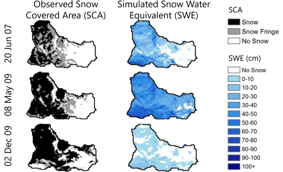
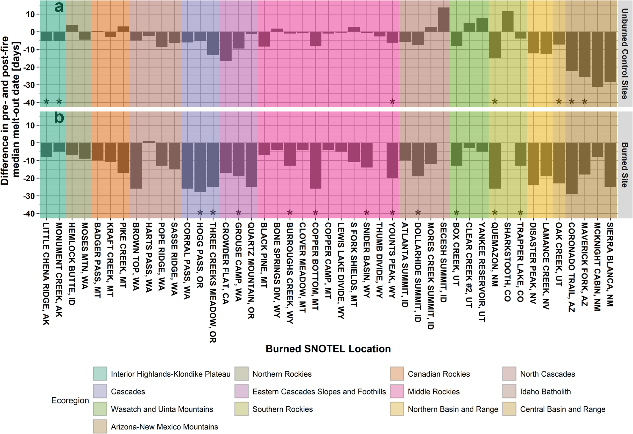
Snowpack is an important source for water supply in many parts of the world. In the western U.S., for example, runoff from snowmelt provides a large majority of annual water supplies. Rain on snowpack can also produce major floods, and the presence of frozen ground can impede infiltration and enhance flood production. Both snowpack and frozen ground are often heterogeneous within watersheds due to spatial variations in the topography, ground cover, and soil properties. Snowpack may also be affected by wildfires, which are becoming more common in the West. We are analyzing the response of snowpack to wildfires and developing improved methods to model the spatial and temporal patterns of snowpack and frozen ground in watersheds and their responses to wildfires. These methods are expected to improve the accuracy of water management tools and flood forecasting procedures.
- Giovando, J., J.D. Niemann, and S.R. Fassnacht, 2024, "Wildfire Impacts for Temperature Index Snowpack Model Parameters," Hydrologic Processes, 38:e15334, doi: 10.1002/hyp.15334.
- Follum, M.L., J.D. Niemann, and S.R. Fassnacht, 2019, “A Comparison of Snowmelt-Derived Streamflow from Temperature-Index and Modified-Temperature-Index Snow Models,” Hydrologic Processes, 33:3030-3045, doi: 10.1002/hyp.13545.
- Follum, M.L., J.D. Niemann, J. Parno, and C.W. Downer, 2018, “A Simple Temperature-Based Method to Estimate Heterogeneous Frozen Ground within a Distributed Watershed Model,” Hydrology and Earth System Sciences, 22, 2669-2688, doi: 10.5194/hess-22-2669-2018.
- Follum, M.L., C.W. Downer, J.D. Niemann, S.M. Roylance, and C.M. Voyovich, 2015, “A Radiation-Derived Temperature-Index Snow Routine for the GSSHA Hydrologic Model,” Journal of Hydrology, 529, 723-736, doi: 10.1016/j.jhydrol.2015.08.044.
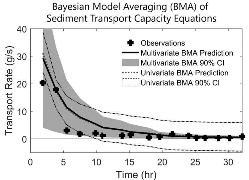
Many water agencies face decisions that involve the potential for economic losses, environmental impacts, and even loss of life if made incorrectly. These decisions are often based on the results of models that simulate watershed hydrology, channel flow, and/or sediment transport. However, the predictions from these models include substantial uncertainty. We are developing practical tools to quantify and ultimately reduce the uncertainty associated with hydrologic, hydraulic, and geomorphic models. These tools aim to identify and characterize uncertainties due to the assumed mathematical structure of the model as well as the uncertainty due to parameter estimation and model inputs. Our uncertainty estimation methods are used by the U.S. Bureau of Reclamation. Ultimately, these tools could result in more reliable predictions and more efficient designs of water infrastructure.
- Jung, J.Y., J.D. Niemann, and B.P. Greimann, 2018, “Combining Predictions and Assessing Uncertainty from Sediment Transport Equations using Multivariate Bayesian Model Averaging,” Journal of Hydraulic Engineering, 144(4): 04018008, doi: 10.1061/(ASCE)HY.1943-7900.0001436.
- Jung, J.Y., J.D. Niemann, and B.P. Greimann, 2017, “Modeling Input Errors to Improve Uncertainty Estimates for One-Dimensional Sediment Transport Models,” Stochastic Environmental Research and Risk Assessment, 1-16, doi: 10.1007/s00477-017-1495-8.
- Sabatine, S.M., J.D. Niemann, and B.P. Greimann, 2015, “Evaluation of Parameter and Model Uncertainty in Simple Applications of a 1D Sediment Transport Model,” Journal of Hydraulic Engineering, 1-13, 04015002, doi: 10.1061/(ASCE)HY.1943-7900.0000992.
- Ruark, M.D., J.D. Niemann, B.P. Greimann, and M. Arabi, 2011, “A Method for Assessing Impacts of Parameter Uncertainty in Sediment Transport Modeling Applications,” Journal of Hydraulic Engineering, 137, 6, 623-636, doi: 10.1061/(ASCE)HY.1943-7900.0000343.
- Tripp, D.R., and J.D. Niemann, 2008, “Evaluating the Parameter Identifiability and Structural Validity of a Probability-Distributed Model for Soil Moisture,” Journal of Hydrology, 353, 93-108, doi: 10.1016/j.jhydrol.2008.01.028.
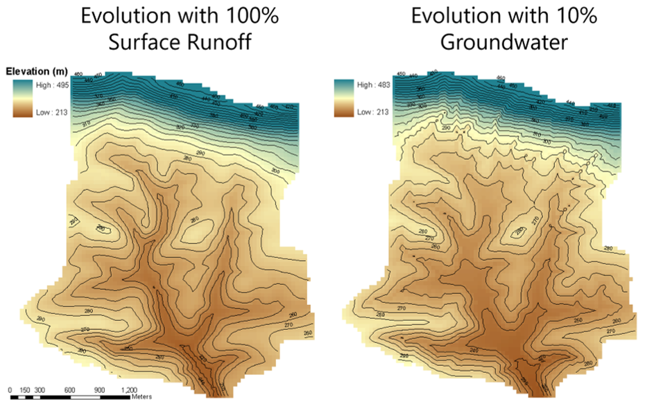
One of the more exciting advances in geomorphological research is the development of sophisticated computer models that simulate the evolution of river basins over long periods of time. These models successfully reproduce many empirical features of river basin topography including dendritic river networks, concave profiles of stream courses, and convex profiles of hillslopes. These models can be used to understand the long-term impacts of climate and land-use changes, as well as the movement of sediment and long-lived pollutants in basins. We are developing better representations of hydrologic processes in these models and studying the role these processes play in landscape evolution.
- Huang, X., and J.D. Niemann, 2014, “Simulating the Impacts of Small Convective Storms and Channel Transmission Losses on Gully Evolution,” Military Geoscience in the Twenty-First Century, Reviews in Engineering Geology, The Geological Society of America, R.S. Harmon, S.E. Baker, and E.V. McDonald, editors, 131-146.
- Coleman, M.L, J.D. Niemann, and E.P. Jacobs, 2009, “Reconstruction of Hillslope and Valley Paleotopography by Application of a Geomorphic Model,” Computers and Geosciences, 35, 1776-1784, doi: 10.1016/j.cageo.2008.07.006.
- Huang, X., and J.D. Niemann, 2008, “How do Streamflow Generation Mechanisms Affect Watershed Hypsometry?” Earth Surface Processes and Landforms, 33, 751-772, doi: 10.1002/esp.1573.
- Huang, X., and J.D. Niemann, 2006, “Modelling the Potential Impacts of Groundwater Hydrology on Long-Term Landscape Evolution,” Earth Surface Processes and Landforms, 31(14), 1802-1823, doi: 10.1002/esp.1369.
- Huang, X., and J.D. Niemann, 2006, “An Evaluation of the Geomorphically Effective Event for Fluvial Processes Over Long Periods,” Journal of Geophysical Research, 111, F03015, doi:10.1029/2006JF000477.
- Niemann, J.D., R.L. Bras, and D. Veneziano, 2003, “A Physically-Based Interpolation Method for Fluvially Eroded Topography,” Water Resources Research, 39(1), 1017, doi:10.1029/2001WR001050.
- Niemann, J.D., N.M. Gasparini, G.E. Tucker, and R.L. Bras, 2001, “A Quantitative Evaluation of Playfair's Law and Its Use in Testing Long-Term Stream Erosion Models,” Earth Surface Processes and Landforms, 26: 1317-1332, doi: 10.1002/esp.272.
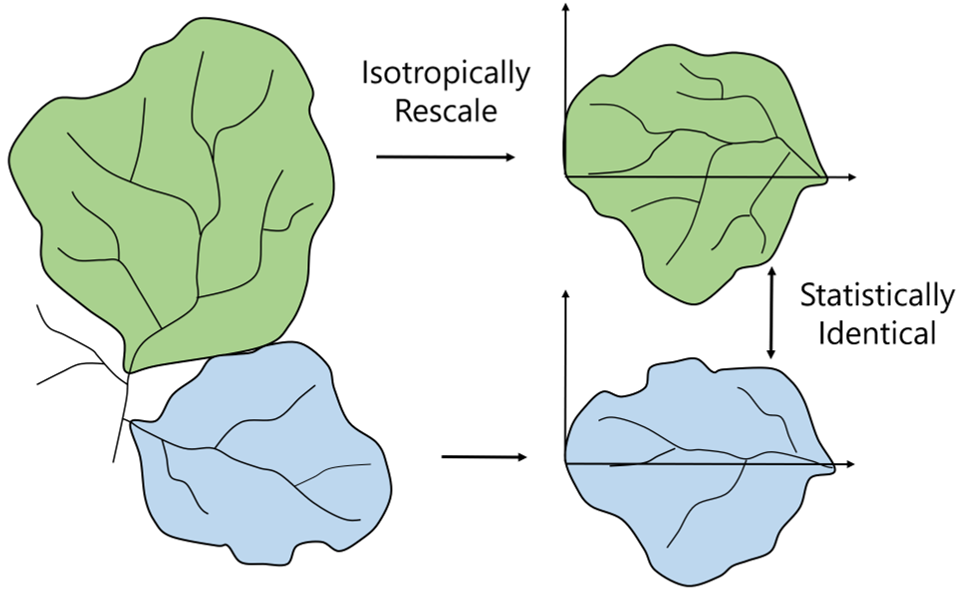
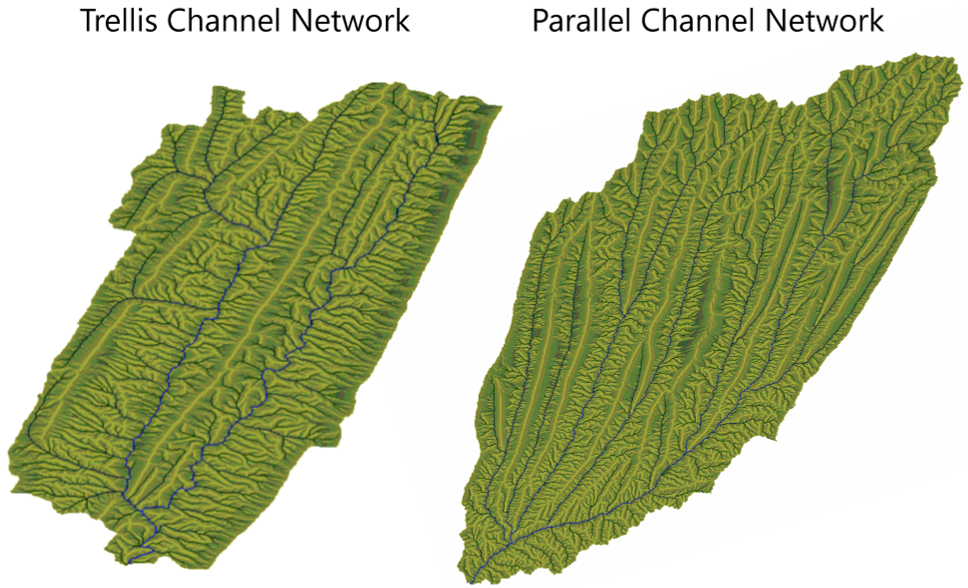
River basin topography has a very interesting property: it often appears similar when viewed at different magnifications. Without an indication of scale, it is difficult to determine whether a photograph of a river basin displays one hundred square kilometers or ten thousand square kilometers. This property is known as scaling invariance and is closely related to fractals and chaos. Many hydrologic variables exhibit this tendency including precipitation rates, soil moisture patterns, and channel networks. In fact, a wide variety of natural objects have fractal geometry. Scaling invariance is useful to hydrologists because it statistically relates the properties of small features to those of large features. Thus, it can help characterize, simulate, and interpolate hydrologic variables. We are examining scaling invariance of hydrologic and geomorphologic phenomena. Specifically, we are quantitatively characterizing the scaling invariance, understanding its dynamic origin, and exploring deviations from scaling.
- Pereira-Claren, A., J. Gironas, J.D. Niemann, P. Passalacqua, A. Mejia, and C. Escauriaza, 2019, “Planform Geometry and Relief Characterization of Drainage Networks in Steep Environments: An Analysis of Chilean Andean Basins,” Geomorphology, 341, 46-64, doi: 10.1016/j.geomorph.2019.05.011.
- Jung, K., J.D. Niemann, and X. Huang, 2011, “Under What Conditions Do Parallel River Networks Occur?” Geomorphology, 132, 260-271, doi: 10.1016/j.geomorph.2011.05.014.
- Mejía, A.I., and J.D. Niemann, 2008, “Identification and Characterization of Dendritic, Parallel, Pinnate, Rectangular, and Trellis Networks Based on Deviations from Planform Self-Similarity,” Journal of Geophysical Research, 113, F02015, doi:10.1029/2007JF000781.
- Niemann, J.D., and L.E. Hasbargen, 2005, “A Comparison of Experimental and Natural Drainage Basin Morphology Across a Range of Scales,” Journal of Geophysical Research, 110, F04017, doi:10.1029/2004JF000204.
- Niemann, J.D., R.L. Bras, D. Veneziano, and A. Rinaldo, 2001, “Impacts of Surface Elevation on the Growth and Scaling Properties of Simulated River Networks,” Geomorphology, 40: 37-55, doi: 10.1016/S0169-555X(01)00036-8.
- Veneziano, D., and J.D. Niemann, 2000, “Self-Similarity and Multifractality of Fluvial Erosion Topography: 1. Mathematical Conditions and Physical Origin,” Water Resources Research, 36(7): 1923-1936, doi: 10.1029/2000WR900053.
- Veneziano, D., and J.D. Niemann, 2000, “Self-Similarity and Multifractality of Fluvial Erosion Topography: 2. Scaling Properties,” Water Resources Research, 36(7): 1937-1951, doi: 10.1029/2000WR900054.
- Veneziano, D., R.L. Bras, and J.D. Niemann, 1996, “Nonlinearity and Self-Similarity of Rainfall in Time and a Stochastic Model,” Journal of Geophysical Research, 101(D21): 26371-26392, doi: 10.1029/96JD01658.