![]()
TREX: Two-Dimensional Runoff Erosion and Export
Spatially Distributed Model To Assess Watershed Hydrology, Sediment Transport, and Contaminant Transport and Fate
Model Development
The starting point
for TREX development was CASC2D (Julien and Saghafian, 1991; Julien et al. 1995;
Johnson et al. 2000; Ogden and Julien, 2002; Julien and Rojas, 2002). The
basic framework is an event-based model that simulates overland flow, surface
soil erosion and deposition, channel flow and sediment transport through stream
channels. As part of TREX development, the hydrologic and sediment transport
components of CASC2D were significantly expanded and enhanced to support flood modeling
and chemical transport features (Velleux, 2005; England, 2005; Velleux et al. 2006;
England et al. 2007; Velleux et al. 2008). Chemical transport and fate components
were formulated based on those in the USEPA WASP/IPX series of stream water quality models
(Ambrose et al. 1993; Velleux et al. 2001) to create a fully distributed model to simulate
chemical transport and fate at the watershed scale. A conceptual diagram of chemical
model processes is presented below.
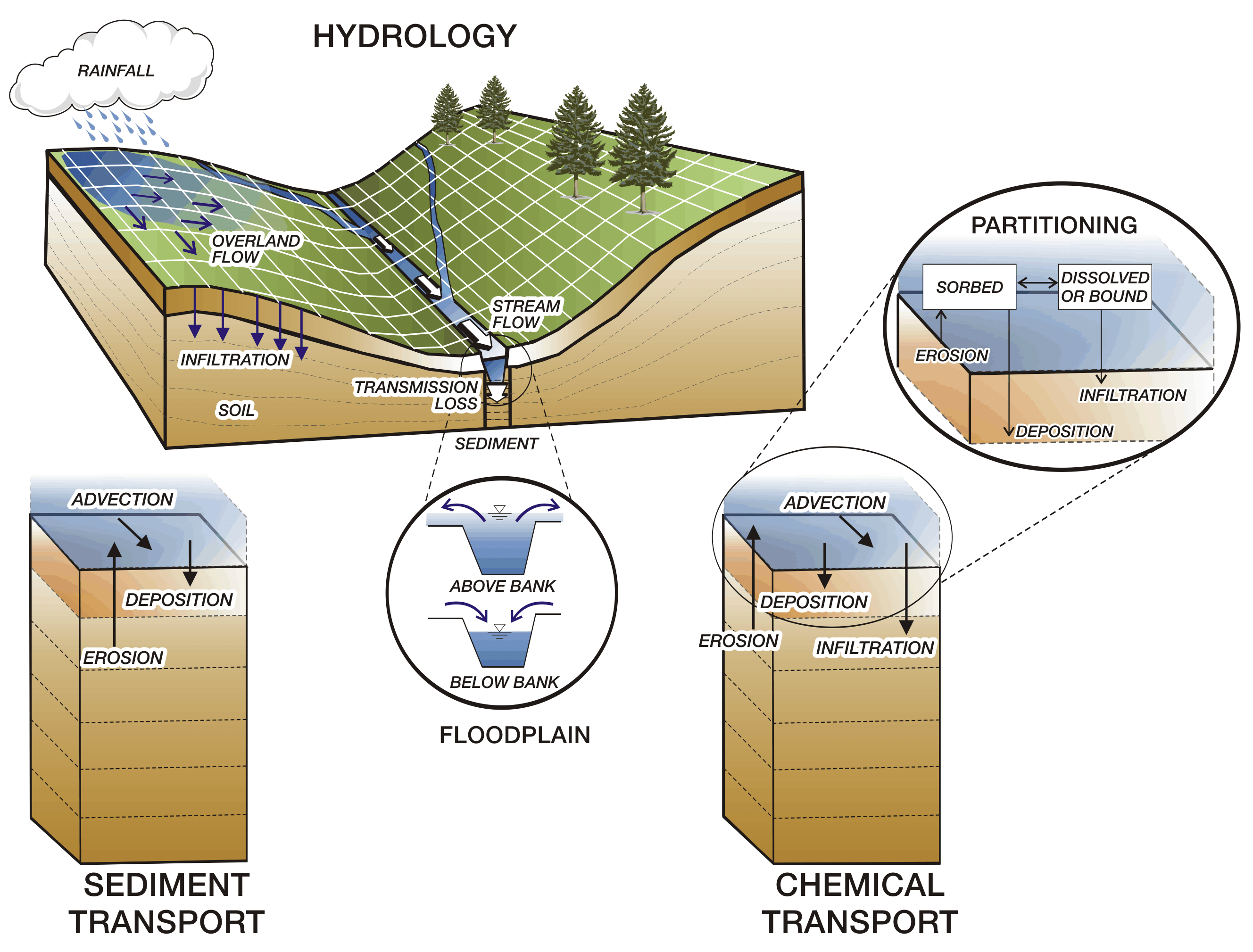
TREX Model Framework
(Velleux et al. 2008)
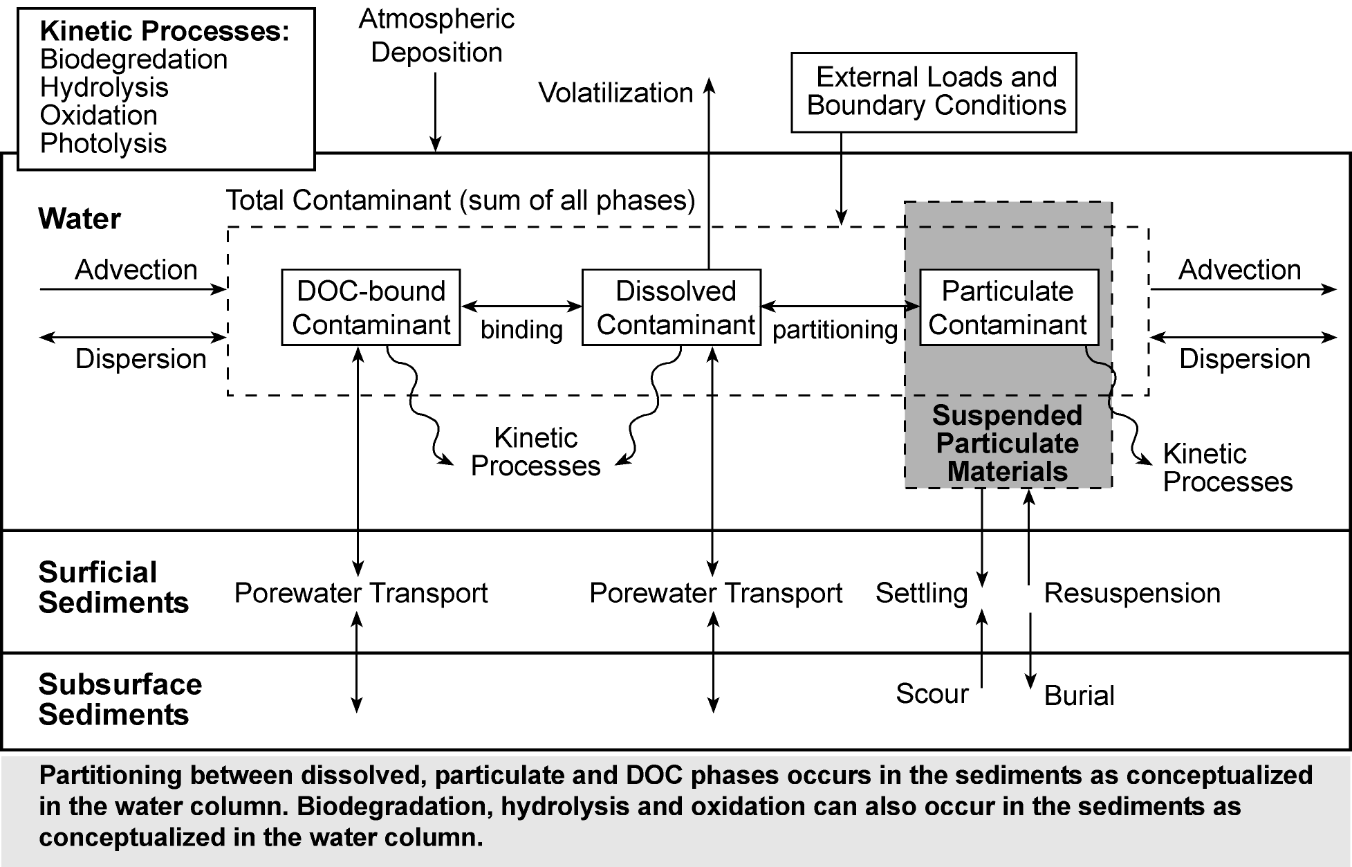
Chemical transport and fate processes
in TREX (after Velleux et al. 2001)
Modeled Processes
The hydrologic processes
in the model are:
The model state variables are water depth in the overland plane and stream channels.
Rainfall can be uniform or distributed in both time and space. When spatially distributed
rainfall is simulated, areal rainfall estimates are interpolated from point rain gage data
using an inverse distance weighting approach. Interception and surface storage are
simulated as equivalent depths.
The sediment transport processes in the model are:
All processes occur in both the overland plane and stream channels. Any number of
particle sizes can be simulated. Advection is computed from flow and concentration.
Erosion and deposition rates are calculated as a function of the hydraulic
properties of the flow, the physical properties of the soils and sediments such as
particle grain size and surface characteristics such as slope.
The chemical transport and fate processes in the model include:
All processes can occur in both the overland plane and stream channels. Any number
of chemicals can be simulated. Advection is computed from flow and concentration.
Partitioning can be simulated on a concentration or organic carbon normalized
basis.
References
Ambrose, R.B., Martin, J.L. and Wool, T.A. 1993. WASP5, A hydrodynamic and water
quality model - Model theory, user’s manual, and programmer’s guide. U.S. Environmental
Protection Agency, Office of Research and Development, Environmental Research Laboratory,
Athens, Georgia.
England, J.F. Jr., 2005. Frequency analysis and two-dimensional simulations of extreme
floods on a large watershed. Ph.D. dissertation, Department of Civil Engineering,
Colorado State Univ., Fort Collins, Colorado.
England, J., Velleux, M., and Julien, P. 2007. Two-dimensional simulations of extreme
floods on a large watershed. Journal of Hydrology, 347(1):229-241.
Johnson, B.E., Julien, P.Y., Molnar, D.K., and Watson, C.C. 2000. The two-dimensional
upland erosion model CASC2D-SED. Journal of the American Water Resources Association,
36(1):31-42.
Julien, P.Y. and Saghafian, B. 1991. CASC2D User’s Manual - A Two Dimensional Watershed
Rainfall-Runoff Model. Department of Civil Engineering, Colorado State University, Fort
Collins, Colorado. Report CER90-91PYJ-BS-12. 66 p.
Julien, P.Y., Saghafian, B., and Ogden, F.L. 1995. Raster-Based hydrologic modeling of
spatially-varied surface runoff. Water Resources Bulletin, AWRA, 31(3):523-536.
Julien, P.Y. and Rojas, R. 2002. Upland erosion modeling with CASC2D-SED. International
Journal of Sediment Research, 17(4):265-274.
Ogden, F.L. and Julien, P.Y. 2002. CASC2D: A Two-Dimensional, Physically-Based,
Hortonian Hydrologic Model. In: Mathematical Models of Small Watershed Hydrology and
Applications, Singh, V.P. and Frevert, D., eds., Water Resources Publications, Littleton,
Colorado. pp. 69-112.
Velleux, M.L. 2005. Spatially distributed model to assess watershed contaminant transport
and fate. Ph.D. dissertation, Department of Civil Engineering, Colorado State University,
Fort Collins, Colorado.
Velleux, M., Westenbroek, S., Ruppel, J., Settles, M., and Endicott, D. 2001. A User’s
Guide to IPX, the In-Place Pollutant Export Water Quality Modeling Framework, Version
2.7.4. U.S. Environmental Protection Agency, Office of Research and Development,
National Health and Environmental Effects Research Laboratory, Mid-Continent Ecology
Division, Large Lakes Research Station, Grosse Ile, Michigan. 179 pp. EPA/600/R-01/079.
Velleux, M., Julien, P., Rojas-Sanchez, R., Clements, W., and England, J. 2006. Simulation
of metals transport and toxicity at a mine-impacted watershed: California Gulch, Colorado.
Environmental Science and Technology, 40(22):6996-7004.
Velleux, M., England, J., and Julien P. 2008. TREX: Spatially Distributed Model to Assess
Watershed Contaminant Transport and Fate. Science of the Total Environment, 404(1):113-128.
Home | Overview | Applications | User Manual | Source Code | Examples | TREX Tools | Research | Contacts | USEPA SAP Review
Department of Civil and Environmental Engineering
-
Colorado State University
Fort Collins, Colorado 80523-2028 USA (970) 491-5048
Last update: 07 August 2018