
Novel forms of urban development aim to engineer systems that replicate natural hydrologic functioning. This includes preservation of near-natural groundwater recharge through infiltration of stormwater close to impervious surfaces where stormwater is generated. A small watershed in the Piedmont province of Maryland, USA is one of the first instrumented watersheds that was recently developed entirely with novel, distributed stormwater management techniques and is used as a case study for the work. This study seeks to understand how these alterations to the natural landscape impact base flow and groundwater – surface water interactions.
Below is a general public summary of this work and its findings.
Stormwater management has been evolving over time. Previously (post- WWII), the way we managed stormwater (runoff from impervious surfaces such as roadways, rooftops, parking lots, etc.) was to pipe it directly to local streams to prevent flooding. While this helped us drive when it rains, it led to damage to urban streams which received large pulses of stormwater during rains, leading to erosion and unhealthy stream habitats (sometimes called the urban stream syndrome).
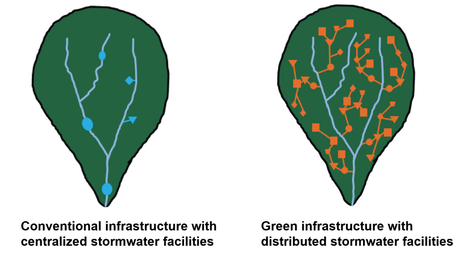
The next type of management, which is the conventional type today, uses detention ponds to store those peak pulses of stormwater and release them later into streams. This helped reduce the highest peak going into streams, but didn’t reduce the overall volume of stormwater, since a detention pond just changes the timing but not the overall of stormwater.
So the latest iteration in stormwater management is what is sometimes called green infrastructure, and other times Low Impact Development, Environmental Site Design, or distributed stormwater management (here I will use green infrastructure). The focus here is to reduce the volume of stormwater entering our streams. This is done by infiltrating water throughout the watershed using facilities such as bioretention cells, vegetated swales, dry wells, and permeable pavement. These facilities are spread throughout the neighborhood so that the stormwater doesn’t concentrate downstream where it is too large in volume to be handled.
I am focusing here on a watershed that uses green infrastructure facilities for stormwater management. The watershed is called Tributary 104, and it is in Clarksburg, Maryland. The watershed was converted from agricultural and forested land to residential suburban between 2004 and 2010.
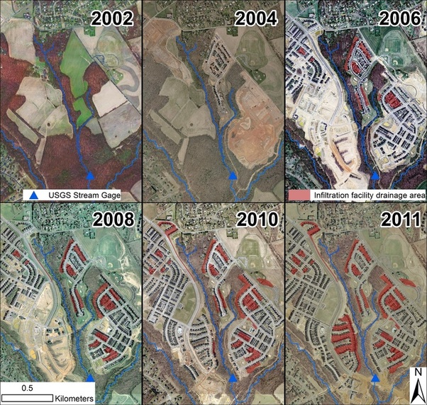
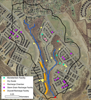
It has 30% impervious surface cover and is 0.43 square miles. It has a USGS stream gage that records streamflow at the watershed outlet, which has operated since 2004. The watershed also has 73 stormwater facilities, put in during development, that are focused on infiltrating stormwater. These include dry wells, bioretention facilities, dry swales, and underground facilities such as recharge chambers.
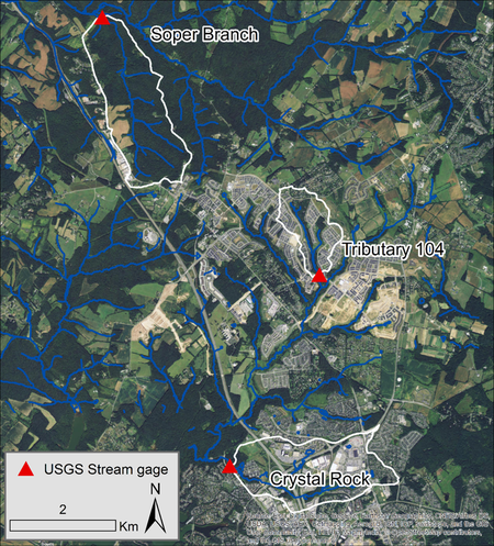
To see how streamflow changed during suburban development in Tributary 104, we had to isolate changes due to suburban development from changes due to normal variations in weather. To do this we compared streamflow in Tributary 104 to changes to two nearby watershed which had stable land cover. Soper Branch is a watershed in Little Bennett Regional Park that is forested. Crystal Rock is a suburban watershed that is 40% impervious and was built in the 1990s using conventional stormwater management (stormwater detention ponds).
We wanted to know how monthly streamflow changed during development, as well as how base flow changed. Base flow is the part of flow in streams that comes from groundwater, which was previously precipitation or stormwater that infiltrated the land surface. Base flow is what keeps streams flowing when it is not raining.
We found that base flow and total monthly streamflow (including both base flow and flow during storm events) significantly increased in Tributary 104 relative to the control watershed during suburban development (2004-2010). The increase in total streamflow is most simply explained by a decrease in evapotranspiration (combination of evaporation and transpiration– use of water by plants). This part of the water cycle makes up the main pathway out of watersheds in this humid region of the country. But with 30% impervious surface cover, we have 30% less vegetation to take up water, which may be causing the increase in streamflow. Some of this water that would have been taking up by plants before suburban development is now being routed to infiltration facilities, and contributing to increased base flow. This is clearly better than having a big reduction in base flow and urban streams drying out, but is still a change from the hydrologic cycle before suburban development.
This work was carried out in collaboration with Dianna Hogan and Stacey Archfield and during this time I was supported by a National Science Foundation Earth Sciences Postdoctoral Fellowship. More information can be found in the open-access journal article: Bhaskar, A.S., D.M. Hogan, and S.A. Archfield, (2016), Urban base flow with Low Impact Development, Hydrological Processes, doi: 10.1002/hyp.10808.